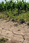
COLUMBIA, Mo. – It’s been a pretty typical July, weather-wise, in Missouri. The only problem is it’s barely June, and high temperatures and lack of rain threaten damage to crops, pastures and lawns.
Related radio news story by Debbie Johnson. For downloadable broadcast-quality audio, contact Johnson at 573-882-9183.
A University of Missouri climatologist said May, and now June, continued a weather trend that set records and prefaced an emerging drought most of the state faces.
“Back to back we’ve seen top 10 records for temperature highs and precipitation lows for Missouri, and we’re breaking various temperature records left and right across the state with a string of some very mild months,” said Pat Guinan, MU Extension state climatologist for the Commercial Ag Program.
The lack of rain is reaching a dire point for drought-stricken areas. In May, preliminary data indicated Missouri only averaged 2.30 inches of rain, ranking it as the eighth driest on record since 1895 for what is typically the wettest month of the year.
Temperatures brought no relief either. Running about 5 degrees above normal, the 70-degree average will likely fall in the top five warmest May periods on record for the state.
When climatologists look at spring – from March to May – it’s just one record-breaking event after another.
“It was our warmest spring on record, which blew the previous record set in 1977 out of the water by 3 degrees,” Guinan said. “That’s significant because typically you break a monthly or seasonal record by a smaller margin.”
You can see the impact in the field.
MU Extension specialists across Missouri observed uneven soybean stands and corn fields where leaves roll from lack of moisture and heat, both signs of drought stress. Pastures and lawns also have that characteristic “crunch” when walked upon due to the browned, dead or dormant grass needing a drink.
Southeast Missouri began experiencing the dryness in April, but it has since spread across the rest of the state. especially after the first week of May.
“It’s called an Omega block, where the upper level pressure pattern takes the shape of the Greek Omega character,” Guinan said. “If you look at a synoptic map of the upper air patterns over the past few weeks, you see a high pressure ridge across the center of the U.S. and trough-like areas of low pressure in the east and west, literally looking like an Omega.
This typifies a blocking pattern, keeping clear skies and little precipitation in the middle part of the country.
Missouri is not alone, with neighboring states starting to feel the scourge of drought. Portions of Kansas, Nebraska, Iowa and Illinois also saw these dry conditions emerge, with a flash drought impacting much of the middle of the U.S.
Historically, a dry May in Missouri doesn’t promise for a good outlook for the rest of the growing season.
“If you have a very dry May, generally the following summers tend to be hotter and drier than normal,” Guinan said. “When you look at the top 15 driest May months on record, only two of the subsequent summers saw precipitation average more than 1 inch above normal.”
The accompanying heat with low humidity also means that evaporation from soils and transpiration from plants accelerates, making the drying out process speed up. This warm weather continues a trend that climatologists have documented for the past year.
“Over the past 12 months there’s only been one month with below normal temperatures, and that was September 2011,” Guinan said. “When you crunch the numbers it’s unprecedented; we haven’t seen a warmer 12-month period, starting last June, since 1895.”
While some rain came through parts of Missouri Monday, significant amounts are needed to replenish water resources above and below the ground. Guinan joins many in hoping more rain will come.
“Hopefully we will see a change and a wetter pattern that sets up soon, because things are going to go downhill very quickly if we don’t.”
Read more http://extension.missouri.edu/news/DisplayStory.aspx?N=1442


